


By Benjamin Stokes
On Sunday, a team called RideSouthLA celebrated the launch of its new bicycle map to the Watts Towers, handing out copies at the southern tip of the massive CicLAvia festival. The map offers a next ride for CicLAvia enthusiasts, who numbered more than 100,000 pedestrians and cyclists, and filled more than 10 miles of streets, from Boyle Heights to MacArthur Park, seeking to reimagine Los Angeles.
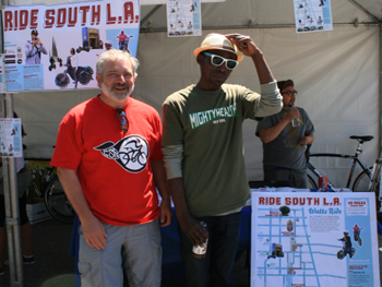 Professor Francois Bar of USC Annenberg Innovation Lab with Tafarai Bayne of T.R.U.S.T. South LA Professor Francois Bar of USC Annenberg Innovation Lab with Tafarai Bayne of T.R.U.S.T. South LA |
One answer came with the RideSouthLA map, which was just printed this week. The map provides a “do it yourself” route for a bike ride in South Los Angeles, from the iconic Watts Towers to the wetlands of Augustus Hawkins Park on Compton Avenue. This was the first printing of the map, and more than 400 free copies were distributed, according to organizers.
Several bicycle clubs from South LA were at CicLAvia, including the East Side Riders, which organized a “feeder ride” to CicLAvia as a group. The Riders were eager to view the map, which features photographs of and by several of their members. Their club is a co-sponsor of the RideSouthLA.com website, and they helped pedal-test the route back in January, using their personal cell phones to photograph the Watts Towers and other community treasures worth sharing.
Like CicLAvia, the map is both about alternative transit and social change in Los Angeles.


Speak Your Mind